
Loading
Daniel B Stephens
  • Markets & Services
    • Laboratory Services
      • Instrumentation/Automation
      • Research/Development
      • Sensor Calibration
      • Soil Properties Testing
    • Environmental Data
      Management
      • Custom Web Applications
      • Data Management
      • GIS/Mapping
      • GLA-Data
      • Site Visualization/Analysis
    • Oil/Gas/Energy
      • Carbon Management
      • Natural Resources
      • Permitting/Compliance
      • Water Supply/Development
    • Engineering
      • Mining
      • Remediation
      • Stormwater
      • Solid Waste
      • Water/Wastewater/Reuse Systems
      • Funding Assistance
    • Natural Resources
      • Biological Services
      • Clean Water Act Compliance
      • Cultural Resources Services
      • Environmental Impact Studies
      • Watershed Management
    • Contaminated Sites
      • Indoor Air Vapor Intrusion and Risk Assessment
      • Operation/Maintenance/Monitoring
      • Petroleum Storage Tank Sites
      • PFAS Investigations
      • Remediation
      • Superfund Sites
      • Site Investigation/Characterization
      • Vadose Zone Hydrology
    • Water Planning/Development
      • Brackish Water/Salinity
      • Engineering
      • Geochemistry
      • Modeling
      • Public Involvement
      • Recharge/Reuse/Recycling
      • Stormwater
      • Sustainable Groundwater Management
      • Vadose Zone Hydrology
      • Watershed Management
      • Water Planning
      • Water Quality
      • Water Rights
      • Water Workshops and Training
      • Wells/Wellfields
      • Funding Assistance
    • Litigation/
      Expert Services
      • Experts
      • Contaminated Sites
      • Indoor Air Vapor Intrusion/Risk Assessment
      • Mining
      • PFAS Investigations
      • Vadose Zone Hydrology
      • Water Rights/Disputes
    • Mining
      • Closure/Reclamation
      • Engineering
      • Environmental Site Characterization/Remediation
      • Hydrogeology/Geochemistry
      • Permitting/Regulatory Compliance
      • Soils/Geotechnical Laboratory Analysis
      • Water Management/Supply
      • Enhanced Metal Recovery
    • Solid Waste
      • Compliance Monitoring
      • Construction Quality Assurance
      • Interim and Final Closure
      • Laboratory Services
      • Modeling
      • Permitting and Design
      • Stormwater Management
  • About
    • Principal Professionals
    • Representative Projects
    • Publications and Water Plans
    • Awards & Rankings
    • Community
  • News
  • Careers
  • Contact
  • Click to open the search input field Click to open the search input field Search
  • Menu Menu
You are here: Home1 / News2 / Events3 / Applying GIS to Geological Investigations for a Sand and Gravel Assessment...

Applying GIS to Geological Investigations for a Sand and Gravel Assessment at Pueblo of Acoma
Events

DBS&A’s Geographic Information Systems (GIS) team will be attending the National Tribal Geographic Information Support Center’s (NTGISC) 9th Annual National Tribal GIS Conference taking place from November 5 through 9, 2018 at the Southwestern Indian Polytechnic Institute in Albuquerque, New Mexico.

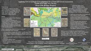
GIS Manager, Kenny Calhoun, GISP; GIS Technician, Samuel Romero; Senior Geochemist, Chris Wolf, P.G.; and Staff Geologist; Chad Johannesen, P.G., co-authored a digital poster for the event, which showcases the benefits of applying a GIS to a Sand and Gravel Assessment that DBS&A performed on behalf of the Pueblo of Acoma Planning and Engineering Department. ArcGIS provided a reliable method for creating maps and performing calculations that were crucial for this assessment project. GIS Analyst, April Molina, GISP, Mr. Calhoun, and Mr. Romero will be present at the conference to discuss DBS&A’s GIS capabilities and experience working with tribal entities.

Acoma has ongoing construction projects including roadways, bridges, and pipelines that require sand and gravel borrow material during construction.  A new bridge project, Mesa Hill Bridge and SP 36 Road Extension Project, is in the early design phase and initial estimates indicate that over 190,000 cubic yards of aggregate will be used during the construction project.  Funding was provided by the Bureau of Indian affairs (BIA), Division of Energy & Mineral Development.

Using a phased approach, DBS&A evaluated the sand and gravel resources at nine sites with seven of the sites within five miles of the Mesa Hill Bridge Project.  Sediment samples were collected with locations recorded using a GPS.  Potential areas containing the aggregate resource were delineated as polygons within ArcGIS based on field observations and the local geology.  The area was calculated for each polygon and using an assumed depth of the sediments, the sediment volume was estimated.  This information was provided to Acoma for deciding which sites could be further investigated.  Maps of the sites were provided to the Southern Pueblo Agency for Cultural and Biological evaluations.

Acoma eliminated several of the nine sites due to cultural reasons, and DBS&A performed additional investigations at four of the remaining sites. At each site, transects were measured using a survey-grade GPS unit to help delineate the surface topography, which was compared and integrated with a digital elevation model (DEM) to ensure that surface control was adequate for calculating sediment volumes.  Test pits were excavated using a back hoe to determine depth of the sediments, to characterize the lithology, and to collect samples for laboratory analyses.  Samples were analyzed for their geotechnical properties following American Association of State Highway Officials (AASHTO) procedures.  A detailed site map, showing the areas evaluated, was prepared in ArcGIS that included a surface geologic map for a five-mile radius around the Mesa Hill Bridge Project using the 1:500,000 Geologic Map of New Mexico created by the New Mexico Bureau of Geology and Mineral Resources.

DBS&A prepared a detailed report that provided ArcGIS maps for each site, geologic cross-sections, laboratory data, and the geologic maps.  Potential volumes of sand and gravel were calculated for each of the sites evaluated in Phase 2.

This year’s conference theme, Impact of New Technologies – Flying into the Future, aims to recognize the various technologies as supporting tools to identify issues and solutions that support the management and protection of Natural Resources, Culture, Land, etc., to achieve greater community decisions that support the well being of tribal communities. Click here to learn more about the conference.

November 7, 2018
Share this entry
  • Share on Facebook
  • Share on WhatsApp
  • Share on LinkedIn
  • Share by Mail
https://www.dbstephens.com/wp-content/uploads/2022/10/DBSA-website-color-logo-300x65.png 0 0 db_stephens_admin https://www.dbstephens.com/wp-content/uploads/2022/10/DBSA-website-color-logo-300x65.png db_stephens_admin2018-11-07 08:54:502018-11-07 08:54:50Applying GIS to Geological Investigations for a Sand and Gravel Assessment at Pueblo of Acoma
Search Search

Recent Posts

  • 2026 Land and Water Summit
  • DBS&A Supports NMED Emerging Contaminants Program
  • Carbon Capture, Utilization, and Storage 2026

Daniel B. Stephens & Associates, Inc.


6501 Americas Parkway NE, Suite 200
Albuquerque, NM 87110

Phone  505-822-9400
Fax  505-822-8877

Locations

  • California

  • Colorado

  • New Mexico

  • Texas

  • Washington, DC

Information

  • Services
  • News
  • Community
  • Contact

Work With Us

DBS&A Careers
© 2026 Daniel B. Stephens & Associates, Inc. | Phoenix Web Design by Kinetik IT
  • Link to LinkedIn
  • Link to Youtube
  • Link to Facebook
  • Employee Intranet
  • Legal notice
Link to: DBS&A Sponsoring California H20 Women Conference Link to: DBS&A Sponsoring California H20 Women Conference DBS&A Sponsoring California H20 Women ConferenceLink to: DBS&A Team Awarded Contract to Prepare Owens Valley Groundwater Basin Groundwater Sustainability Plan Link to: DBS&A Team Awarded Contract to Prepare Owens Valley Groundwater Basin Groundwater Sustainability Plan DBS&A Team Awarded Contract to Prepare Owens Valley Groundwater Basin...
Scroll to top Scroll to top Scroll to top